NOAA’s
National Geodetic Survey and Aircraft
Operations Center have mapped the wreckage of the World Trade
Center in support of recovery and cleanup efforts following the
Sept. 11 terrorist attack. The data are being used to provide
a very accurate geographic network. Building and utility engineers
will be able to determine the location of original foundation
support structures, elevator shafts, basement storage areas and
building utility connections enabling them to concentrate their
digging and recovery efforts in the proper location.
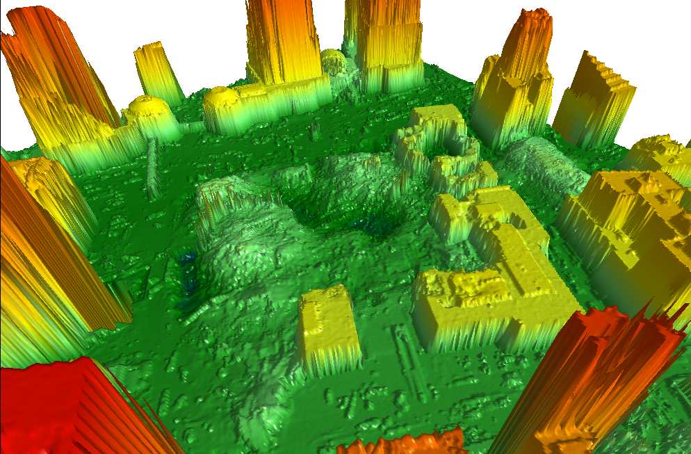
These images will also provide
very accurate height measurements as the recovery efforts descend
into the basement, to mitigate possible flooding from the surrounding
rivers as well as to determine the volume of debris and the reach
needed by cranes to remove it.
larger view. Credit “NOAA.”

|
|
2 and 3. |
|
Digital Surface Models created by the LIDAR system provide very accurate 3-dimensional positioning of the building structures and the surrounding area. The 3-D models, in this case, have helped to locate original support structures, stairwells, elevator shafts, basements, etc. When this data is merged with the high resolution aerial photography taken by NOAA’s Citation aircraft, it will create a very accurate image with relative accuracy around three decimeters. |
NOAA’s efforts in New York
began on the ground on Sept. 15th as NGS field survey personnel
provided the necessary ground support and calibration expertise
for the airborne imaging sensors—high resolution cameras
and laser ranging devices. These airborne and ground-based systems
will produce very accurate map products at ground zero and the
surrounding area affected by the terrorist attack. Both private
industry and
government agencies benefited from these activities.
The NOAA
team used the global positioning system (GPS)
to position both ground and airborne mapping sensors. GPS technology
fixes the latitude, longitude and height of a point on the ground
and in space within five centimeters. Additional support was
provided by the NGS Continuously Operating Reference Stations
(CORS) program, which
used two of its nearby continuously operating GPS sites to collect
data for the remote sensing missions.
Similar work began at the Pentagon on September 26. The New York
mission has concluded, and the Pentagon mission is scheduled
to continue for another week.
The NOAA
Citation jet, N52RF, usually used for remote sensing and
high resolution photography for coastal mapping, was outfitted
with an Optech LIDAR
(Light Detection and Ranging). Collecting both LIDAR data
and high-resolution photography, the Citation flew over a five-square
kilometer area of lower Manhattan.
Flights over the World Trade
Center began Sept. 23 and concluded Sept. 26. The data are currently
being processed. There were two flights lasting four hours each.
The NGS field support team
included Mike Aslaksen, Ed Carlson, and Jason Woolard. The Citation
crew included Lt. Cmdr. Brad Kearse, Lt. Mike Weaver, and Lt.
Will O’Dell (pilots) of the NOAA
Commissioned Corps and Aircraft Operations Center; and Steve
Nicklas of NGS.
The U.S. Army Topological Engineering
Center initiated and coordinated the entire effort. Army TEC
worked closely with NOAA, Optech Inc. and the University of Florida
to produce the images and map products. This collaboration was
a complete success and digital images will be available soon.
Relevant Web Sites
Citation Aircraft
2,
3,
4,
5,
6
Media Contacts:
Greg
Hernandez, NOAA, (202)
482-3091 or Jeanne
Kouhestani, NOAA Office
of Marine and Aviation Operations, (301) 713-3431 ext. 220